Kategorie

Originaldatei (1.280 × 764 Pixel, Dateigröße: 108 KB, MIME-Typ: image/jpeg)
.jpg)
Beschreibung
| Beschreibung |
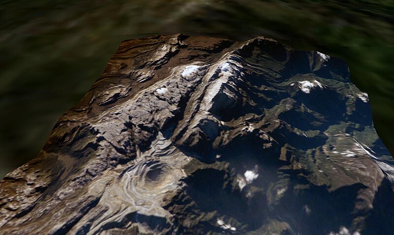
Puncak Jaya, West Papua, Indonesia. The Grasberg (Freeport) copper mine pit is in the foreground, and remnants of the Puncak Jaya glaciers behind. The summit of Puncak Jaya is at the far end of the central rib. Two remnants of the Northwall Firn are to the left of the peak. The Meren Glacier was in the valley between these and the peak, but disappeared sometime between 1994 and 2000[1]. The Carstenz Glacier is immediately right of the peak. (White patches further to the right are clouds, which appear to be on the terrain surface due to the image processing technique used.) At the current retreat rate, all these glaciers will be gone forever inside 10 years, making greater-Australia the first completely ice-free continent on the planet in 100,000 years. (Africa can't win. Kilimanjaro's ice is nearly gone, but there is still a fairly thick glacier left on Mount Kenya, and more in the Ruwenzori.)
worldwind://goto/world=Earth&lat=-4.06986&lon=137.14256&alt=8039&dir=90.3&tilt=52.2 (Imagery mostly cloudy - try Geocover 1990.) Also see |
| Datum | 10. Juni 2006 (Original-Hochladedatum) |
| Quelle |
Made with NASA World Wind from NASA public domain imagery Originally from en.wikipedia; description page is/was here. |
| Urheber | Original uploader was Gergyl at en.wikipedia |
| Genehmigung (Weiternutzung dieser Datei) |
Licensed under the GFDL by the author; Released under the GNU Free Documentation License. |
Lizenz

|
Es ist erlaubt, die Datei unter den Bedingungen der GNU-Lizenz für freie Dokumentation, Version 1.2 oder einer späteren Version, veröffentlicht von der Free Software Foundation, zu kopieren, zu verbreiten und/oder zu modifizieren; es gibt keine unveränderlichen Abschnitte, keinen vorderen und keinen hinteren Umschlagtext.
Der vollständige Text der Lizenz ist im Kapitel GNU-Lizenz für freie Dokumentation verfügbar. |
| Diese Datei ist unter der Creative-Commons-Lizenz „Namensnennung – Weitergabe unter gleichen Bedingungen 3.0 nicht portiert“ lizenziert. | ||
| Namensnennung: Gergyl at the English Wikipedia | ||
| ||
| Diese Lizenzmarkierung wurde auf Grund der GFDL-Lizenzaktualisierung hinzugefügt. |
Ursprüngliches Datei-Logbuch
(All user names refer to en.wikipedia)
- 2006-06-10 09:38 Gergyl 1280×764×8 (110347 bytes)
- 2006-06-10 08:32 Gergyl 1280×764×8 (110462 bytes) Puncak Jaya, Indonesia. A June 2005 NASA astronaut photograph draped over the NASA World Wind SRTM90 DTM and viewed from a similar angle to the 1936 and 1972 USGS photos of this tropical glacier group. worldwind://goto/world=Earth&lat=-4.06651&lon=137.1
Dateiversionen
Klicke auf einen Zeitpunkt, um diese Version zu laden.
| Version vom | Vorschaubild | Maße | Benutzer | Kommentar | |
|---|---|---|---|---|---|
| aktuell | 14:45, 26. Apr. 2007 | | 1.280 × 764 (108 KB) | wikimediacommons>Alfonso"~commonswiki | {{Information |Description=en:Puncak Jaya, en:West Papua, en:Indonesia. The Grasberg (Freeport) copper mine pit is in the foreground, and remnants of the Puncak Jaya glaciers behind. The summ |
Dateiverwendung
Keine Seiten verwenden diese Datei.
.jpg)